
Visiting Braund Country - Armidale, New South Wales, Australia
Armidale, home of many branch 1 and 4 Braunds, is located in the New England area of New South Wales. New England has no clearly-defined boundaries, though the most common description of New England is the Northern Tablelands highland area which forms part of the Great Dividing Range, from the Moonbi Range in the south to the border of Queensland in the north, an area of some 320 km (199 miles) from north to south and 130 km (81 miles) east to west. More specifically, on 22 May 1839, the New England District was gazetted thus:
New England District: Bounded on the east by a line north by compass from the top of Werrikimber Mountain which is at the head of the Hastings River; on the south by a line west by compass from the top of Werrikimber Mountain to the Great Dividing Range; on the west by the western extreme of the Great Dividing Range so as to include the Tableland and on the north the boundary is indefinite.[1]
[1] At http://en.wikipedia.org/wiki/New_England_%28New_South_Wales%29

Approximate Location of New England
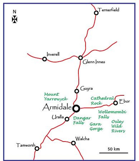
The Major Towns and Attractions in the Armidale Region of New England
The topography of the region is dominated by the Northern Tablelands plateau. The eastern side of the plateau is rugged, drained by numerous swift-flowing rivers with attendant gorges and waterfalls. Extensive areas are more than 900 m (2,953 ft) above sea-level. The western side is less rugged. New England lies in the temperate zone, and the climate is generally free from extremes of heat and cold. Winter frosts are common on the Northern Tablelands and winter snow is not unusual in this area. Most rain falls in late summer and early autumn with an annual average rainfall of about 800 mm (32”). The eastern escarpment has falls of around 2,000 mm (79”) on average.
Aboriginal groups have occupied the New England Tablelands region for many thousands of years, the Anaiwan (or Nganaywana) people settling around Armidale.[2]
There is a strong oral history suggesting seasonal movement of Aboriginal people through the rugged gorge system, between the coastal plains and tablelands. The tablelands were occupied during summer and autumn, communities moving either to the coast or the western river systems for winter. Trading between groups most likely involved exchanges of stone tools and local hardwood. Mammals such as kangaroo and possum provided food, clothing and decoration.
European settlement was initiated by the explorer John Oxley in 1818 and squatters, in search of land suitable for grazing, followed in the early 1830s. This period saw the founding of Armidale.[3] In 1846, Armidale had a population of only 76 but already boasted a post office, court house, flour mill, church and several inns. The population had reached more than 500 by 1851 and became the central administrative town of the bioregion. By 1861, the population of Armidale had grown to some 4,200 people and the town grew substantially over the next 40 years. It became an established centre for education and strengthened its position as a regional capital by the 1890s. It became a municipality in 1863 and was declared a city in 1885. Gold had been found just to the south of Armidale as early as 1851 and further finds in the area attracted several thousand settlers to the region. Gold and antimony provided a substantial economic stimulation to Armidale. Cattle grazing dominated the landscape in the early years of settlement and this was supplemented significantly by the end of the nineteenth century when fencing and improved pastures encouraged sheep grazing.
Alongside the growth of industry, agriculture and population was the development of transport. Construction of the Northern Tablelands railway service commenced in the 1870s and the Main North railway line reached Armidale in 1883. Further developments in the rails service to Armidale were to occupy the attention of both Frederick and George Braund. Armidale today marks the northern-most station on the Main North railway. Before the advent of the railway, the movement of goods and people was by road. Trade to the south, primarily to the shipping port of Newcastle, was via the Great North Road (later, the New England Highway), but the great distance (some 400 km or 250 miles) and the poor condition of the road, made this journey time-consuming (and correspondingly costly). An alternative route, Major’s Line, was then considered across the mountains to Port Macquarie, following the initial route taken by Oxley. Started in 1838, the construction of this road was delayed following the weakening of the pastoral industry. Eventually, this road became known as the Oxley Highway. The Peel line, surveyed in 1832, linked the New England Tablelands with Port Stephens but was abandoned after a few years of use.
But many and varied problems faced these pioneers. As well as moulding the land for animals and crops and constructing roads and, later, railways for transporting goods and people the pioneers endured harsh living conditions, resistance from the local aboriginal people and threats from bushrangers and other delinquent elements. Understandably, the local indigenous people resented the intrusion of the flocks and herds of the white squatters into their land. Rather than confront the settlers, many of whom had firearms, the aborigines started slaughtering the settlers’ stock and, when the opportunity arose, the shepherds and herdsmen too. Retaliation from the settlers was inevitable and many confrontations between black and white ensued, the New England area witnessing fighting between aborigines and settlers during the 1840s.[4]
Bushrangers were many during the latter half of the nineteenth century and several operated in the New England area. They were a constant danger on the early roads of New England. Notable bushrangers in New England were Thomas Gregory, John Roach (aka Hugh Duggan; aka Henry Howard, Jack Bradshaw and Riley the Bushranger. Probably the most famous (or infamous) bushranger in the Armidale area was Captain Thunderbolt (Frederick [Fred] Wordsworth Ward) who robbed properties, mail coaches and hotels. He was shot dead by Constable Walker at Kentucky Creek, some 30 km (19 miles) SW of Armidale in May 1870.[5]
[2] Comments on the early history of the New England Tablelands are taken from
http://www.environment.nsw.gov.au/bioregions/NewEnglandTableland-RegionalHistory.htm, http://en.wikipedia.org/wiki/New_England_%28New_South_Wales%29, http://www.migrationheritage.nsw.gov.au/mhc-reports/DifferentSightsOnline.pdf and from a paper written by Mr. J. F. Campbell, L. S., and read before a meeting of members of the Royal Australian Historical Society, and reported in the Scone Advocate 22 September 1922, 3 October 1922 and 6 October 1922.
[3] Armidale was named after Armadale on the Isle of Skye, the ancestral home of George McDonald, the Commissioner for Crown Lands at this time. (Wikipedia).
[4] Wikipedia.
[5] Fred, born in 1835, was the son of convict Michael Ward and his wife Sophia. At http://www.thunderboltbushranger.com.au/frederick-ward-biography.html. Carol Baxter.

A Wanted Poster for Captain Thunderbolt [6]
Delinquent elements further hampered the colonisation attempts of the early squatters. Made up primarily of convicts who had been assigned to work for private individuals, these ‘delinquent elements’ were treated as slave labour and lived under most difficult circumstances. The paper by J.F. Campbell (see footnote, above) contains a revealing quote from The Sydney Herald of 11 April 1836:
We beg leave to add our own personal knowledge of the fact that the interior of the colony is infested with gangs of cattle stealers and other disorderly persons, whose depredations are carried out to an alarming extent. These gangs consist of freed men, who have served short sentences, or those of long sentences holding tickets-of-leave, who combine with the assigned servants to plunder the herds of their masters. Many of these men are known to possess large herds of cattle, obtained in a very short time by a series of schemes for stealing them.
The early years of colonisation by white settlers in the Tablelands were far from easy but by the time the Braund family arrived in 1889 many of the issues had been addressed. Conditions in Armidale were still basic, but industry and agriculture were developing and road and rail networks were in place. Armidale had been proclaimed a city just four years earlier.
A birds-eye view of Armidale (below), from 1884, presents the basic layout of the city. Of particular interest to the Braund family is the Armidale New Stores, shown in the bottom margin of the bird’s-eye view as the 4th sketch from the right. In 1884, the store was owned by John Moore, but was bought by Frederick Braund in 1889. The store was to remain in Braund hands until 1940. The building still stands.
[6] Gloucester Advocate.

Bird's Eye View of the City of Armidale 1884 [7]

The Armidale New Stores
Armidale Today
According to the 2021 census, Armidale had a population of some 24, 000 people. Aboriginal and Torres Strait Islander people made up 8% of the population, 74 % of people were born in Australia, the next most common countries of birth being Iraq 2.4%, England 2.0%, India 1.1%, Nepal 1.1%, and New Zealand 1.0%. At an elevation of almost 1,000 m (3,280 ft) above sea level, Armidale is Australia's highest city.[8] It is reached easily by air, road or train.
Armidale is still known as the cathedral city, boasting two – Saints Mary and Joseph (Catholic) and St. Peters (Anglican). The Braund family had long-lasting and close ties with the latter. It is home to the University of New England and offers a wide range of cultural attractions by way of art galleries (New England Regional Art Museum, Armidale Art Gallery and Armidale and Region Aboriginal Cultural Centre and Keeping Place), museums (Natural History Museum, Railway Museum and Folk Museum) and vineyards.
Several homesteads are to be found in the Armidale region, but the most significant is Saumarez Homestead, located a short distance from the centre of Armidale. The site was first settled by Europeans in the 1830s, the two-storey Edwardian mansion dating from the 1880s. Today, the interior of the homestead remains largely untouched, while outside the homestead displays a collection of artifacts illustrating its pastoral heritage from 1870 through to 1970.
Probably the biggest attraction in New England is the large number of national parks. The Dangar Falls and Gorge, and Gara Gorge, 22 km (14 miles) south-east of Armidale both offer impressive scenery and bush walks as well as the Blue Hole, which is commonly used for swimming. The remains of Australia's first public hydro-electric scheme can be seen here. Cathedral Rock National Park is 70 km (43 miles) east of Armidale and lies between the Guy Fawkes River and the Macleay Range. The highest peak of the New England Tableland, Round Mountain, is located in the park. Hiking, camping, picnicking and bird watching are popular. Black cockatoos, a rare turquoise parrot and a wedge-tailed eagle can be found circling the surrounding cliffs in search of prey.
In the Oxley Wild Rivers National Park approximately 40 km (25 miles) due east of Armidale, the Wollomombi Falls are atop the Wollomombi Gorge near the confluence of the Wollomombi River with the Chandler River. The Chandler Falls are on the Chandler River, adjacent to the Wollomombi Falls. The falls descend from an elevation of 907 m (2,976 ft) above sea level in one drop of 100 m (330 ft), with a total descent that ranges in height between 150 and 230 m (490 and 750 ft) depending on the flow of the river. At one time they were believed to be the tallest in Australia. However, recent geographical revisions place them at second or third tallest, depending on the source, after the Tin Mine Falls in the Snowy Mountains and the Wallaman Falls, near Ingham, Queensland. Several camp grounds and walking tracks are adjacent to the Wollomombi Falls and provide access to the waterfall.
The Mount Yarrowyck Nature Reserve, some 32 km (20 miles) west of Armidale, contains an Aboriginal cultural walk, a 3-km (1.9 mile) return track, running along the granite slopes of the mountain to an impressive cave painting site.
Other attractions include gem fossicking at the Wooldridge site (near Uralla), some 22 km (14 miles) south-west of Armidale. Uralla also houses the grave of Captain Thunderbolt and is one of many sites in the Armidale area that make up The Captain Thunderbolt Sites, so called because of their association with the bushranger. All these properties were added to the New South Wales State Heritage Register on 20 July 2012.
[7] Supplement to the Illustrated Sydney News 5 July, 1884.
[8] In comparison, Scafell Pike, in the Lake District National Park, is England's highest mountain (978 m).

Michael Braund's Book From Bideford to Armidale and Beyond: a tale of the Braund family, is an extensive account of this branch of the family. Contact us for details of how to obtain a copy.